2025 Preliminary Hurricane Season Forecast 15 days ago
February 7, 2025
- The 2025 Hurricane Season should have fewer impacts than 2024.
- 2018 is the closest analog.
- Unlike last year, there are currently no clear landfall signals.
- We will issue our high-impact area forecast map with the April update.
- An El Niño may develop, but likely won't be a huge factor if it does.
Forecast according to the Power & Impact Scale
Named Storms: 15-19 ( Saffir Simpson, same)
Category 1 or greater hurricanes: 7-9 ( Saffir Simpson, same)
Category 2.5 (start of Power & Impact major hurricane classification): 3
Saffir-Simpson Hurricane Wind Scale Forecast
Named Storms: 15-19
Total Hurricanes: 7-9
Major Hurricanes: 2-3
ACE Index: 120-150
Impact Forecast
Tropical Storm Conditions: 5-7
Total Hurricanes: 3-4
Major Hurricanes: 1-2
Commentary
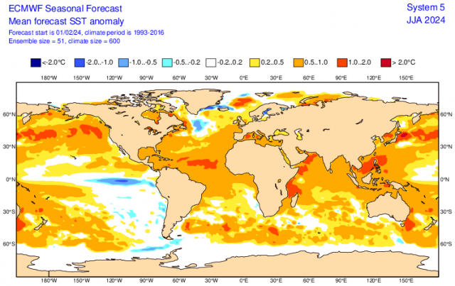
The forecast is based on the overall cooling of SSTs in the Atlantic and forecasted warming in the ENSO areas of the Pacific. Even now, the Main Development Region is much cooler than last year at this time. 2024:
.png)
Now:
.png)
I believe the Euro has the right idea on the ENSO region, which is the opposite of last year when the strong El Niño collapsed. This year, the Euro is forecasting a weak La Niña reversing to an El Niño by the hurricane season.
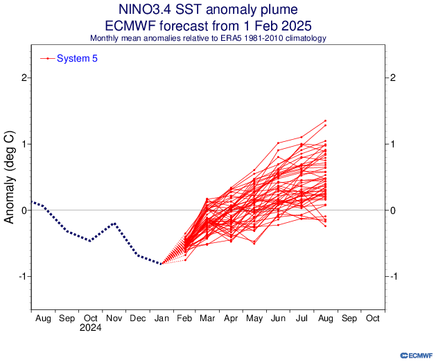
The consensus of the models is not as impressed with that chance (compiled by IRI).
.png)
The consensus is a very low chance for El Niño. I am following the example of the 2017-18 pattern that resulted in a similar winter to what we will wind up with here, after a similar hurricane season in 2017. That was actually the hurricane season with the most damage and 2023 was second. The winter MJO rotation has been close to 2017-18, indicating there is an overall similarity in the global pattern.
Finally, I don't believe a weak El Niño, given the current global warmth, would be as big of a deal when it comes to the total number of storms as it may have had in the past. Based on the ONI we had a strong El Niño in 2023 and there were more total storms than in 2024. The key was almost all were out at sea. If we see a clustering of tracks, it's liable to be to the east of last year and coming more from systems passing to the north, and not to the south of the Caribbean islands.
A look at the Euro SSTs for May-July:
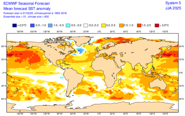
Still, it doesn't have an El Niño. The Atlantic is much cooler than last year, and the swath of warmer water is shown to the north. This suggests less activity in the Main Development Region, but the potential for rapid feedback farther to the north and in close to the coast is there, so it will be a different look, with its own share of issues.
Note that last year's forecasted pattern stood out like a sore thumb:
The Verdict
For our 2024 forecast, there is no question that what we saw in December 2023 stood out so much that we hit our forecast on the mark for an active hurricane season from hell, the second costliest on record. I was overdone in the numbers game, though. With a less impressive look this year, I am expecting true tropical cyclones to be less, but there is going to be a better chance for the weak "ham sandwich" storms in the North Atlantic to pump up numbers.
This season will be a year where in-close development is a concern, as it has been recently, due to the distortion of overall feedback patterns likely brought about by the distortion of warming, the Global Wind Oscillation, and Sea Level Pressure patterns.
As a side note, we had a well below average global ACE last year due to the Western Pacific being so far down. I expect a more normal number in the Western Pacific this year.